
Summary and conclusions:
In 2011 Centro won a Local Sustainable Transport Fund award to deliver a series of schemes to promote public transport use and active travel across the West Midlands. In Birmingham major improvements were to be made to (amongst others) the Bristol Road and Pershore Road corridors, some of which relate to better cycling infrastructure. The Birmingham City council's policy is for a modal shift leading to 5% of journeys by bike traffic (i.e. over three times the current level). Will this investment help secure this growth?
Push Bikes has studied the results of this investment hoping that lessons can be learnt for improving future plans (including Birmingham Cycling Revolution schemes). We have concluded that the major investments on both Bristol and Pershore roads have little impact on commuter cycling because there are no improvements to 'on highway' cycling that would make it safer for commuter cyclists who by and large do not find attractive the shared paths that are the main feature of the investment. Other cycling journeys - to local centres, shops, etc - may benefit but only if the signing and side road crossings are improved. We do not believe that highway engineers have adequately met the fundamental needs of all cycling journeys - comfort, reduced delay, unnecessary exertion and avoidance of hazards. The Council should provide the political will to insist on the implementation of high quality cycling infrastructure.
Corridor Improvements
1: Bristol Road
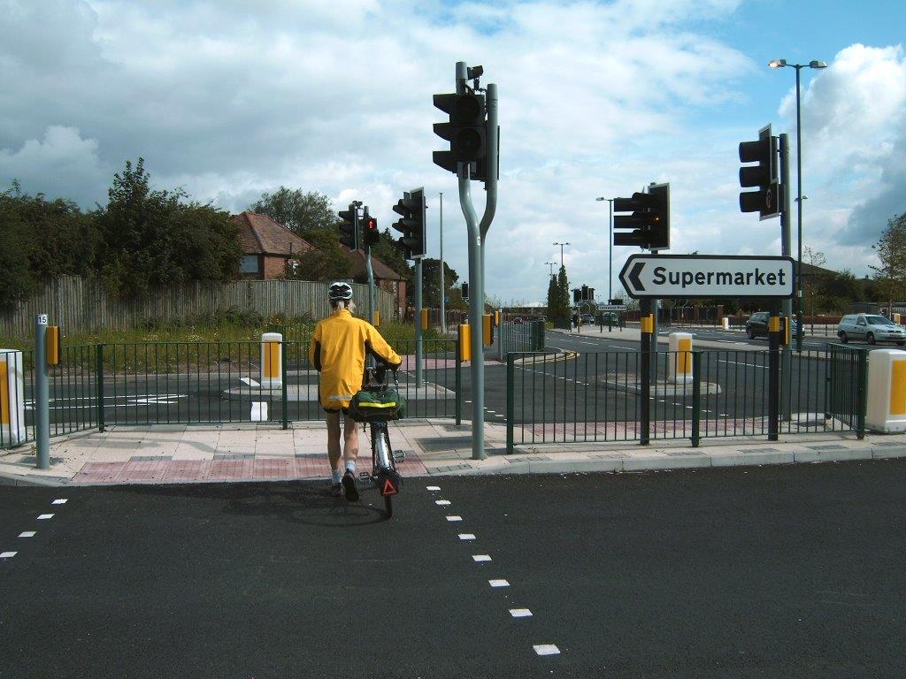
The major expenditure has been incurred on the upgrading to Toucans of several controlled crossings, and the provision of shared use paths on both sides of Bristol Road between the city boundary and the Ring Road (Belgrave Middleway). In total this has amounted to approximately £2.4million.
After phase one was completed in 2014, Push Bikes held a led ride of 20 participants along the completed section between Bournbrook Road (at University of Birmingham) and the Ring Road to assess its suitability for commuters and leisure cyclists. We concluded that the frequency with which cyclists were required to give way and the danger of crossing side roads (particularly Priory Road) made it unattractive and dangerous for any type of cycling journey. Additionally, the uneven surface, the street clutter and debris made journeys slow and uncomfortable. Our report was sent to both Birmingham City councillors and Centro.
Later phases covering the remaining portions of the corridor have similar faults - only more so. Paths are narrower, road crossings and exits more numerous and street clutter more troublesome. Very noticeable (and particularly irritating) is the difference in quality of the surface between the smooth tarmac of the carriageway (used by well sprung vehicles) and the rough paths used by unsprung bikes. It emphasises the second class (or worse) treatment of cyclists in the mind of the highway engineers.

 The shared paths along the Selly Oak and Northfield by passes although better surfaced require cyclists to negotiate up to 8 multi stage light controlled crossings.
Completely ignored by the LSTF was the Selly Oak High Street section of Bristol Road and the approaches and horrors of the signaled junction at Chapel Lane with Bristol Road; cyclists heading south or east have no cycle lanes and no protection. Not surprisingly few choose to take the risk and opt for safer but less direct alternatives.
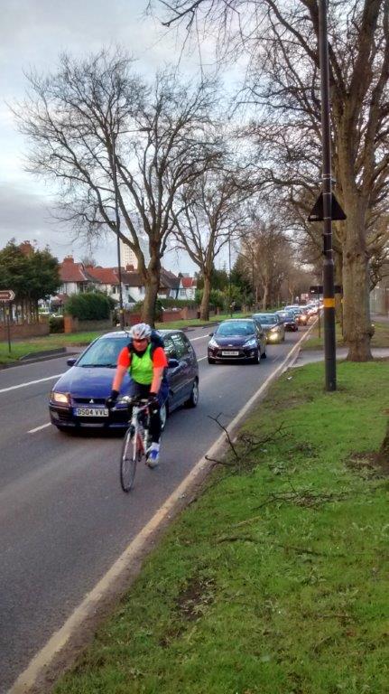
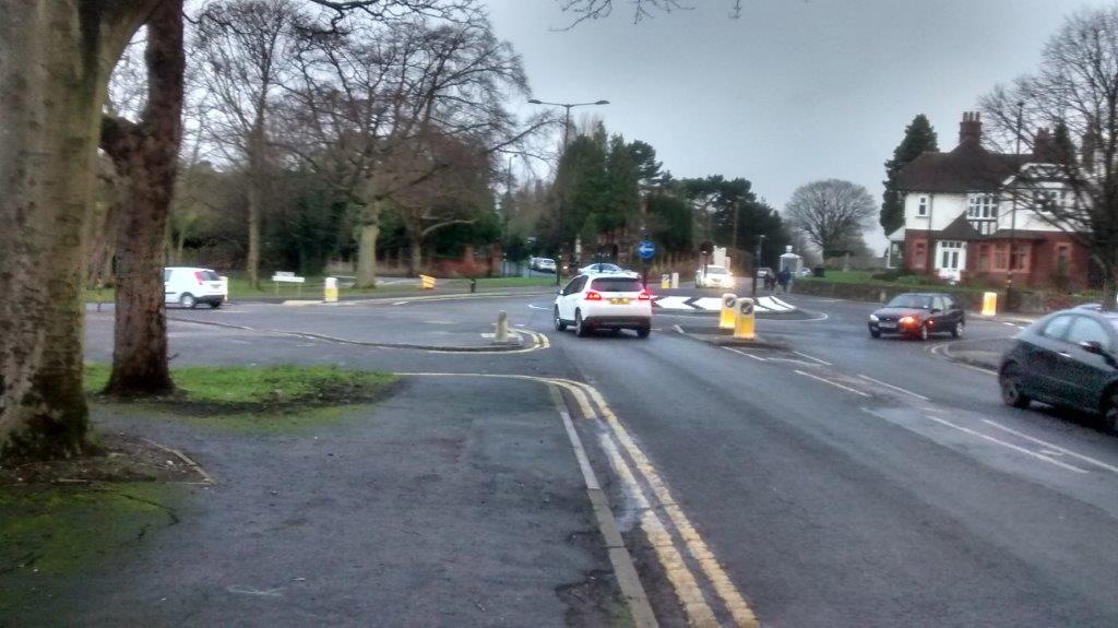
For some of the route between Selly Oak and Northfield cycle lanes have been retained on the carriageway, presumably in recognition that the carriageway is wide and less congested; (could it also be to save money?). However it is also faster and has busy intersections (photo) subject to severe accidents (recently a 3 car, near fatal collision) so is extremely hazardous for cyclists. Where cycling on the southbound carriageway would interfere with car parking outside The Royal Orthopedic Hospital, cyclists are directed on to the rough shared path with several unprotected entrance/exits.


But not on the northbound carriageway which is equally congested with parked vehicles (photo). On the northbound shared path between Manor Farm and Middle Park Road there are conflicting signs and also a profusion of signs showing shared and segregated paths.
Bristol Road Conclusion:
The Birmingham City council's policy is for a modal shift leading to 5% of journeys by bike traffic (i.e. over three times the current level). Will this investment of £2.4million help secure this growth? No published figures are available but casual observations doubt that many commuter cyclists (identifiable by high viz/lights/faster speed) use the 'improved' paths preferring to ride on the carriageway. Some increase is observed on the shared use paths however in local cycling (identifiable by less urgency/casual dress) though overall not sufficient to achieve a significant increase in cycling journeys.
This is not surprising since, apart from segregating cyclists from fast moving vehicles, these 'improvements' do not fulfil other basic cycling requirements - comfort, reduced delay, unnecessary exertion, and avoidance of hazards. Engineers and highway designers must have this as their objective in all new programmes. Just consider again the difference in treatment of a journey on the shared path and on the road illustrated by this photo. This cyclist is not benefiting from LSTF investment but is choosing his preferred route. As an investment in leading to a significant increase in cycling journeys the Bristol Road scheme has failed.
2: Pershore Road
Few of the £1.6million improvements on Pershore Road were aimed at cyclists. Mainly they were the re-allocation of road space to ease passage of buses and the narrowing of crossings to aid pedestrians. Cyclists were directed by enhanced signage towards the parallel River Rea Route.

One of the consequences of introducing bus lanes is that the opposite carriageway is narrowed or restricted leading to hazardous overtaking sections (noticeably southbound between Balsall Heath Road and Edward Road and also Edgbaston Road and Pebble Mill Road. An alternative shared use path is provided here but, of course, it is subjected to a rough surface, two junctions and a difficult re-entry back onto the carriageway.
Incidentally by prohibiting the left turn exit from Ribblesdale Road to Pershore Road in Stirchley there is a marked reduction in 'rat run' traffic along Oxford Street, Bond Street and Regent Street, as reported by Push Bikes previously.
Pershore Road Conclusion
It is doubtful that the changes made on Pershore Road have significantly improved the cycle journeys made along this corridor. In some respects the introduction of Bus Lanes has made cycling more hazardous.
Area Cycle Network
The Area Cycle Network is part of LSTF award. The aim was to create a more integrated network of cycle facilities in the area surrounding the Bristol and Pershore Roads at a final cost of roughly £432,000.
The Area Cycle Network includes improvements for cyclists such as upgrading existing off-road ‘green’ walking routes to make them suitable for cyclists, signing cyclists via existing quieter roads, with lining and signing measures where appropriate and implementing controlled crossings where cycle routes cross main roads.
The LSTF objective and Push Bikes' comments on each section is shown below.
Pebble Mill Road - Shared use paths to be introduced on both sides.
Comment: There are no signs of a shared path on the south side of this road. A major missed opportunity in view of the new Birmingham Dental Hospital opening soon. There are no cycle routes for patients, staff and visitors to this hospital. A signed route from Moseley to the University crosses Pershore Road adjacent to the site but no connecting path is signed. Unbelievable!

Great Park to Rubery - Improved signage leading to NCN5.
Comment: The new signs erected at several roundabouts have no destination (other than '5' and also point to the wrong exits. Why are there no signs FROM NCN5 to Rubery, Great Park, etc? No attempt has been made to improve the access to NCN5 which has an unnecessary barrier readily bypassed via a muddy area (see photo).
Longbridge Island - Installation of new Toucan Crossing.
This scheme has been withdrawn due to other plans within the Longbridge redevelopment.
Lickey Road - Introduction of shared use paths on both footways.
Comment: All signed as per plans. Surfaces reasonable but, of course, suffer from all the usual disadvantages of shared use paths with multiple crossings.
Northfield-Cotteridge - Improved cycle route through railway bridge on Popes Lane.
Comment: This scheme is considered too long term and costly to fit into LSTF. It would have provided the only safe connection with the River Rea path (NCN 5) for residents of much of Bournville, Northfield and Cotteridge. Shame!
Church Road, Northfield - A short shared path bypassing a signal controlled junction
Comment: No comment

Bournbrook - New path between Northfield Road and Lamont Close, California.
Comment: Good path and entrance, well signed. However the connection with the northbound Bournbrook Way is through narrow barriers that severely inhibit all bikes.
When challenged the BCC engineer replied that the issue of the use of K-barrier was a major topic of conversation during the development of the scheme and a proposal to install a more cycle friendly barrier elsewhere on the scheme received adverse comments. It is alleged that the area has trouble with motorcycles and the removal of the barriers was seen as opening the area up to increased problems.
Harbourne Road [sic] s/b Harborne Lane - New Toucan crossing and signage.
Comment: Good except for poor surface and lacking sign and destination at connection with Bournbrook Way though this should be improved when a more direct path to the Toucan crossing is constructed.
Bournville Lane - Continuation of Merritt's Brook Greenway from Manor Park to Bournville Station
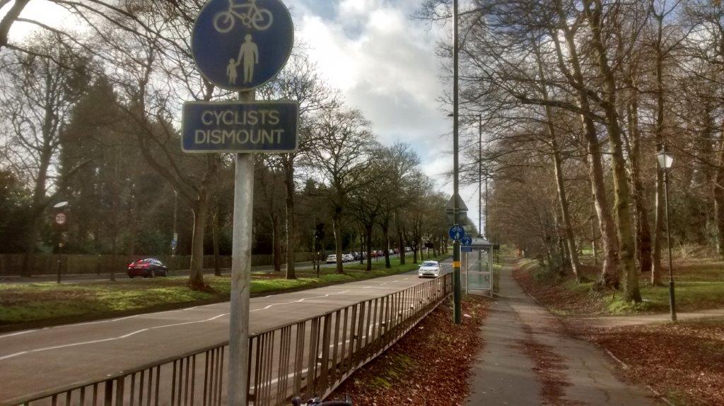
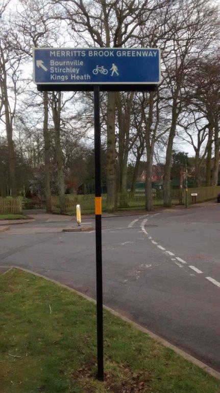
Comment: Although marked on the planned route there are no signs through the private housing estate between Manor Park and Bristol Road. A dropped kerb is essential here because the path is blocked by parked cars. Shared use paths are not signed on either side of Bournville Lane leading up to Bristol Road. Where signed the route is good (except for an unnecessary 'Cyclists Dismount' sign) with destinations in both directions until the entrance to Bournville Park. From there the path was intended to cross Linden Road and use the tarmac surface around Cadbury's recreational area but they refused permission and the alternative shared path along Bournville Lane to Bournville station and Stirchley was rejected. The signs on the Merritts Brook Greenway are superb - showing several destinations in both directions. However by shortening the route there is now a distinct lack of continuity with no guidance about reaching Stirchley or Kings Heath. It is vital that paths link communities and that good signage give guidance.
Umberslade Road & Heelers Road - Route connecting Bournville and Birmingham University.
Comment: On road with adequate signs giving destinations. The route would be better if at Tiverton Road/Bristol Road traffic signals the route could go straight on and contra flow along Dale Road.
Castle Road, Middle Road - On Road connection with Bournbrook Way and Weoley Castle
Comment: Nothing there!
Castle Road, Weoley Road, College Walk - Continuation of above route crossing Bristol Road connecting to Bournville.
Comment: This is a pathetic scheme - there are occasional arrows but no destination signs so no clue about where the route leads. It is very doubtful if anyone recognises it as a cycle route - can you spot the sign on this photo of Gibbins Road and Weoley Park Road? Further on, the route beyond Bristol Road on College Walk is not signed at all.
BCC response: College Walk is a private road and belongs to Bournville Village Trust with the Birmingham University having a right of access. There was a very great concern from the owners that by signing the route as a formal route could give the public rights over the land which could make it a public right of way and therefore give the public a formal right to use it. At the moment the public are free to use the road because the BVT allow them too. Bournville Village Trust (BVT) has also declined to get the road adopted by the Highway Authority.
Conclusion
These individual routes should be very useful for local journeys and, as stated in the award document, to connect with main cycling routes. They should be a cost effective way of improving cycling infrastructure across the city - certainly in comparison with the far greater sums spent on Bristol and Pershore roads. A network of cycling routes to local centres should be a simple, low cost, non confrontational (win-win) method of encouraging more cycling journeys.
However they cannot be effective unless:
- The possible destinations are clearly signed-in both directions.
- Detailed signposting is also important in drawing attention to other road users which may encourage their wider use.
- Routes need to make full use of pathways through estates, parks and other open spaces that facilitate short cuts -accessible by bikes not cars.
- No 'Cyclist Dismount' signs and no barriers
- The use of barriers to restrict entry by cycles on cycle paths cannot be justified. Danger from motorbikes is a facile excuse -usually unsubstantiated and must be tackled in other ways. Sustrans and the Canal & River Trust have recognised this and have met with little opposition.
- Safe and secure parking is available at destinations.
Many of these routes currently fail many of these tests. Push Bikes needs to keep applying pressure to BCC if the advantages of these routes are to be achieved.
Also noticeable has been the reluctance of private businesses (BVT, Cadbury) and pressure groups to restrict cycling (e.g. barriers). There is a real need to educate people against this view.
Recommendations:
Push Bikes would like to support the city Council in implementing infrastructure that encourages more, safer cycling journeys. To achieve the successful modal shift in cycling there has to be political will insisting on well designed, quality routes that fulfill the fundamental needs of all cycling journeys - comfort, reduced delay, unnecessary exertion, and avoidance of hazards. It is necessary to avoid compromises even if limited resources mean fewer schemes.
Shared use pavement on Bristol Road 001

Crossing on Northfield bypass

Shared use pavement on Bristol Road 002

Car parked in cycle lane on Bristol Road

Shared use pavement on Bristol Road 004

Cycle lane on shared use pavement on Bristol Road

Pershore Road 1

Pershore Road 2

Barriers on NCN5

Barrier on Bournbrook Way

Signpost on Merritts Brook Greenway

Spot the cycle route


