October Safari: Cannon Hill Park to A38 link

Cycle Crossing on the Pershore Road Priory Road Junction

In October 2022 a few members of Push Bikes cycled from Selly Oak to Perry Barr to look at new cycling infrastructure (a so-called cycling infrastructure safari). In particular, we looked at Selly Oak, the link from Cannon Hill Park to the A38 blue route, and the extension of the A34 blue route to Perry Barr. In this article I am looking at the link from Cannon Hill Park to the A38 blue route, which was mainly funded through a national government junction safety fund from 2018. The Pershore Road / Priory Road junction was chosen for the scheme because of the killing of Dr Suzanna Bull in 2017 as she was cycling across it.

At the end of this article I've included photos of the route with comments - you might want to skip ahead to those and then come back to the detailed discussion, as it may make more sense after you have seen the photos.

Overall impression of the route

This spur off the A38 route adds a safe traffic-free link to Cannon Hill Park which is generally good quality, but there are some design flaws that will have an impact on how comfortable and attractive it is to use. At the Pershore Road / Priory Road junction the safety of people walking across the junction has been greatly improved from the previous situation with no signal controlled pedestrian crossings at all, although the situation for people cycling along Pershore Road has potentially been worsened.

Detailed discussion

Birmingham City Council (BCC) needs to adopt a network approach to planning cycle routes, rather than developing each new linear route in isolation. The failings of that approach are evident in the tight staggered toucan crossing at the Bristol Road / Priory Road junction that connects this route to the A38 cycle track, and also in the poor conditions for cycle users proceeding along Pershore Road across the junction with Priory Road. Moving forward, LTN 1/20 states that all new schemes should provide appropriate cycling links at junctions for all directions people may cycle (see section 10.3.2), so hopefully BCC planners will take that onboard. The linear routes that BCC has delivered along the A38 and A34, in particular, are great to cycle on, but they don't cover all the different directions that people may want to cycle - the goal must be to develop a dense network of cycle infrastructure so that the whole of Birmingham is attractive and safe to cycle around.

In the original consultation on the A38 route, we pointed out that there would have to be an extension of the cycle track down Priory Road, and that that should be incorporated into the original design. Although our comments were ignored at the time, we have subsequently been proven right. In the consultation on this scheme, we pointed out that there would be difficulties for people cycling along Pershore Road and that the plans should be amended to accommodate people cycling in that direction. Again our comments were ignored, and the consequence is a dangerous implementation of segregated cycle lanes creating conflict points between people cycling straight ahead and motor traffic turning left. We don't spend time responding to consultations because we have nothing better to do with our time, but because we believe that our suggestions would improve the plans that are put forward. It would be good to see changes made to plans based on our suggestions.

Moving on from the two main junctions, along Priory Road, the cycle track has a vertical kerb that drops down to the adjacent footpath, which is a bad idea. Elsewhere in Birmingham trapezoidal strips have been used between cycle tracks and footpaths to provide an edge that can be felt by people with visual impairments, but which does not present a hazard to cycles (see section 6.2.8 of LTN 1/20). This is particularly useful in sections where there are space constraints on the width available to active travel, such over the Soho Loop canal bridge on Dudley Road (see the photos below). The raised cycle track alongside Priory Road also has an issue where it dips down for a pedestrian crossing - on this section of downhill track, where people may be cycling at 15 mph, that dip may take people by surprise and lead to accidents. It would have been better to gradually raise the footpath to the level of the cycle track at that point, to avoid sudden changes in levels on the cycle track.

On the section of the route opposite Edgbaston Stadium, it crosses two junctions - first the junction for The Ashes road to a development of private flats, and the second for the entrance to the Cannon Hill car park. At the mouth of The Ashes, the toucan crossing has been upgraded and straightened, giving a direct crossing experience for people walking and cycling. However, at the entrance to the Cannon Hill car park, the cycle track has give-way markings for the junction mouth, contrary to the plans in the initial consultation, because of concerns that inattentive drivers would crash into the back of cars turning into the car park. The highway here has been designed to smooth the path for poor driving, rather than facilitating progress for people cycling. The minimum that should have been done was to build out the pavement (and cycle track) to narrow the junction mouth to reduce the speed with which motor vehicles can turn in and out, as well as reducing the distance that people need to walk and cycle across. However, the changes to the Highway Code in January 2022 (after the designs were finalised, but before the work was completed) mean that car drivers should now give way to people waiting to cross this junction, resulting in the situation that breaking up the cycle track was intended to avoid. The message from the government through those changes is that people driving motor vehicles should expect vehicles in front of them to stop at junction mouths, and they should be looking out for that. Highways engineers should not be designing junctions that smooth the path for poor driving, but instead implementing designs that make life easier for people walking and cycling across junctions.


Tags: 

Cannon Hill Park Entrance

The entrance to Cannon Hill Park, showing the toucan crossing for the old NCN 5 route, and the new cycle track extension to Bristol Road.
This shows the entrance to Cannon Hill Park on the left, with the cycle track along Edgbaston Road going towards Pershore Road. The toucan crossing is for the River Rea cycle route into the city centre, with a shared-use pavement to enable both people walking and cycling to use the crossing. The pavement has been widened on this side of the entrance, to provide extra space for the end of the cycle route. The desire line for people cycling along this route is straight across the space where people would wait for the toucan crossing. Arrangements like this can cause issues, but as this particular toucan crossing has one of the fastest response times in Birmingham, it is unlikely that there will regularly be large groups of people waiting for the light here.

Cycle track on Edgbaston Road

Cycle track on Edgbaston Road facing the cricket ground.
This section of cycle track from the Cannon Hill Park entrance on Edgbaston Road along to the entrance of the car park has been taken out of the carriageway. Previously there was a large hatched area in the middle of the carriageway, and there have been problems with speeding, as shown by the presence of a speed camera. Rationalising the width of the carriageway helps to calm the motor traffic as well as providing more space for active travel. Substantial concrete blocks have been placed to stop cars from entering the cycle track or knocking over the flexible plastic wands - something that has been a problem elsewhere in Birmingham. An extra benefit of a wide cycle track like this alongside a pavement is that the pavement becomes more comfortable for people walking here, as there is greater separation from the motor traffic.

Cycle Track Approaching Car Park Entrance

Bi-directional cycle track approaching the Cannon Hill car park entrance.
This photo shows the transition from the cycle track on the carriageway to the pavement next to the Cannon Hill car park entrance. The cycle track is at the same level as the footpath, with a raised strip of paint separating the two. The sign seems to suggest that this is a shared-use pavement, despite the separate cycle track here. The drainage strip across the cycle track is important - there are several points on the Bristol Road cycle track that develop large puddles because they do not have sufficient drainage.

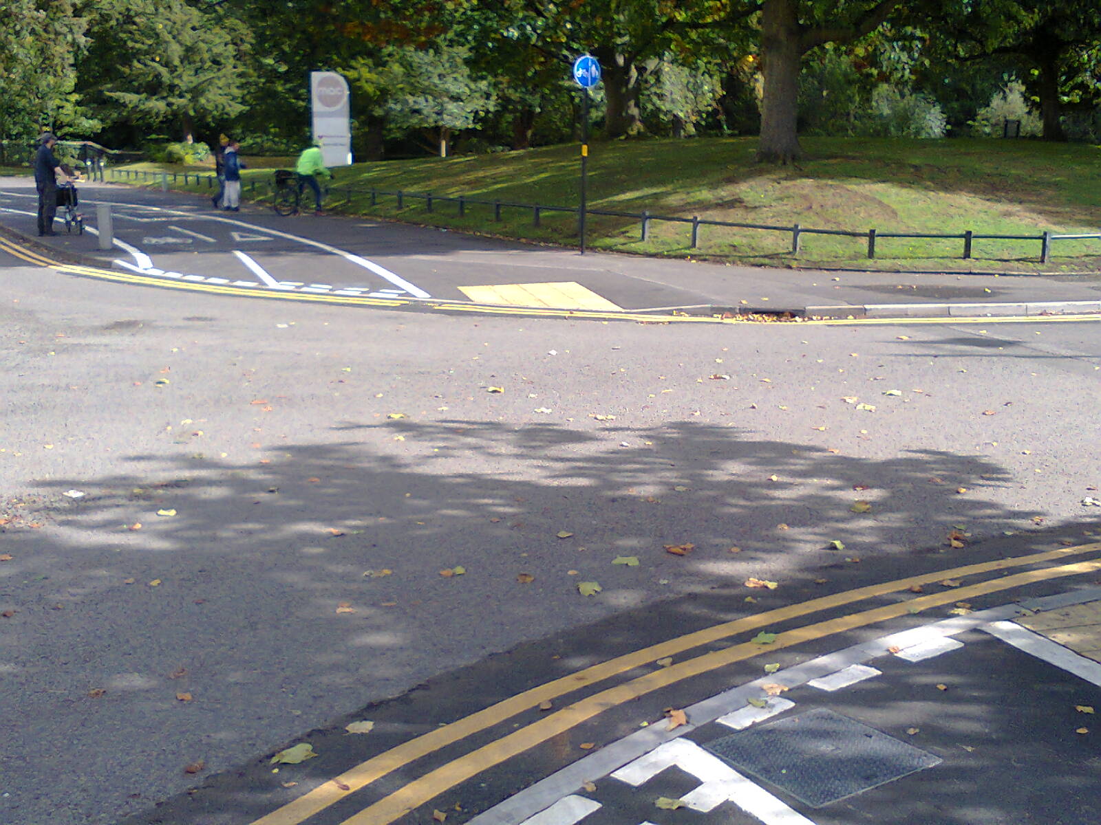
Entrance to Cannon Hill Car Park

The entrance to Cannon Hill car park, with give-way markings for the cycle track.
In the original consultation, the cycle track continued across this driveway so that cars had to give way as they turned in. We were told that there were concerns about turning cars being hit by unobservant drivers behind them, and so it was decided that the cycle track would have to give-way for the driveway. Breaking up the continuity of a cycle track like this reduces the attractiveness of it, and can reduce how many people use the cycle track. In addition, wide splayed junction mouths like this increase the distance that cycle users have to cross, as well as increasing the speed at which motor vehicles are driven in and out of the junction. At the least, the mouth of this driveway should have been narrowed, so that motor traffic turning in and out had to go more slowly, and so that people walking and cycling across this driveway had a smaller distance to cover.

Diagonal Cycle Crossing Over Edgbaston Road

Diagonal cycle crossing over Edgbaston Road
This style of crossing was initially used in Birmingham on the Bristol Road cycle track, and provides a good solution for taking the bi-directional cycle track from one side of the road to the other. Because the track bends at roughly a 45 degree angle, it is easier for cycle users to proceed at a reasonable speed if they have a green light as they approach the crossing. Cycles move faster than pedestrians, so the crossing does not need as long a cycle as a toucan-crossing would to go straight across the road.

Cycle Crossing on the Pershore Road Priory Road Junction

Cycle crossing on the Pershore Road Priory Road junction
This shows the cycle track crossing straight over Pershore Road at the junction with Priory Road, with the separate left turn lane on Priory Road. Prior to the cycle track installation, there were no safe crossing facilities at this junction and people walking or cycling across were in significant danger. There are low-level lights for the cycle track, but the high-level signs have been covered up - perhaps to prevent confusion for drivers in the left-turn lane. The cycle track here is on the same level as the pavement, with just a raised white-line separating the two.

Pedestrian Crossing at Pershore Road Priory Road Junction
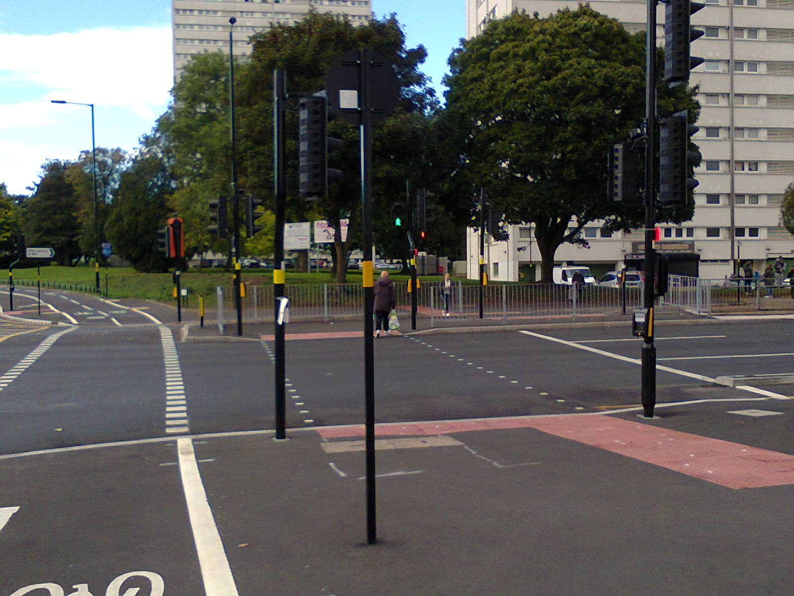
Pedestrian crossing at Pershore Road Priory Road junction
This photo shows the staggered crossing provided for pedestrians alongside the single-stage crossing for cycles. Prior to this cycle scheme, there were no safe pedestrian crossings here, and people walking over this junction were in significant danger. Because cycles move faster than people walk, splitting the pedestrian and cycle crossing means cycle users can be allowed to cross this junction in one stage.

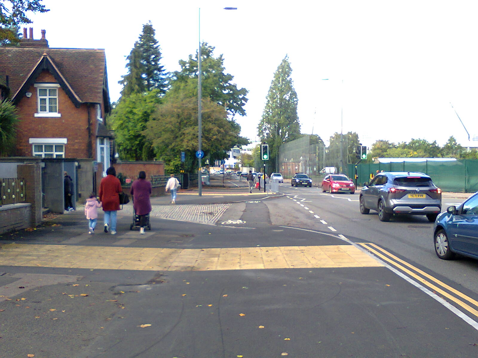
Cycle Lane Along Pershore Road at Priory Road Junction

Segregated cycle lane along Pershore Road approaching the Priory Road junction
A significant issue with the new layout at the Pershore Road / Priory Road junction is the two segregated cycle lanes along Pershore Road approaching the junction, as shown in this photo. If someone stays in this cycle lane, rather than joining the shared use pavement, it is because they wish to carry along Pershore Road, but they receive a green light at the same time as the motor traffic to their right. This means that car drivers who want to turn left, across the path of the cycle user, will have a green light at the same time. This is a dangerous arrangement - if I was cycling along Pershore Road and continuing across this junction, I would not use the cycle lane, but rather stay in the general carriageway, to avoid being taken out by left turning cars. In the original consultation, the designs showed that the cycle lanes would receive a green light before the motor traffic, but that did not happen in our observation of the junction. But those few seconds head start would only benefit cycle users already at the stop line, not those who reach junction while the lights are green. The best immediate solution here would be to fill in this cycle lane with tarmac, taking it up to the height of the pavement, and bring all cycle users on to the shared use pavement. Those who want to continue straight on could then either stay in the general traffic lane, if they are comfortable cycling on Pershore Road, or they could use the staggered pedestrian crossing as a much slower, but safer, alternative.

Cycle Track on Priory Road Approaching Pershore Road
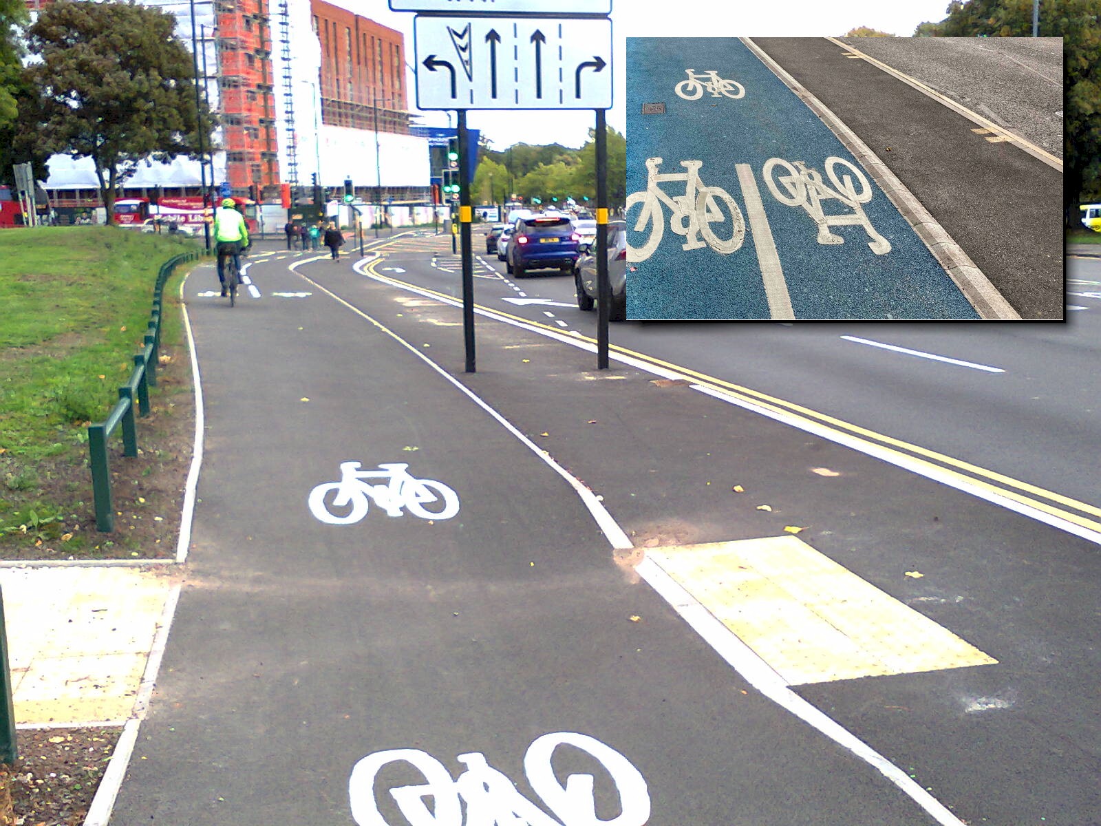
Cycle track on Priory Road approaching Pershore Road
This is the cycle track along Priory Road, with the footpath between the cycle track and the motor traffic. This cycle track is separated from the footpath by a vertical kerb, dropping down from the cycle track to the footpath, except at this crossing of the cycle track where the cycle track dips down to the height of the footpath and back up again (which could give a nasty jolt to cycle users who are not expecting it, potentially causing an accident). It is not clear why a vertical kerb has been used here, when raised painted lines and raised trapezoidal strips have been used elsewhere in Birmingham (as shown by the overlay photo, which is of the cycleway being built on the Dudley Road). This design feels dangerous to me - the cycle track is not 3 meters wide along its whole length, and the vertical drop at the edge reduces the effective width further. If someone was coming down the hill at 15 mph, and a new cycle user was wobbling up the hill, there would not be enough space for them to pass comfortably. Section 5.2 of LTN 1/20 suggests a minimum width of 1 meter for a cycle user travelling in a straight line at over 7 mph, but that that can increase to 1.6 meters for cycle users travelling at less than 7 mph, such as going up hill. As the drop-off is on the ascending side of the cycle track, we can assume that cycle users wobbling up the hill will be trying to wobble away from the drop-off, and will be in the centre of the cycle track. If a different design had been used, with the footpath at the same level as the cycle track, then there would have been space for cycle users to wobble into the footpath, getting around the issues with width constraints. The use of the vertical kerb here is a significant design flaw and it should be avoided in the future.

Bus Stop Bypass on Priory Road

Cycle track bypassing a bus stop on Priory Road
Apart from the vertical kerb separating the cycle track and the footpath (see my comments on the other photo of the cycle track on Priory Road), this is a well designed section of cycle track. There is plenty of space for people to wait for the bus, and the cycle track curves around the back with no sharp turns. We can see the lights of the Bristol Road / Priory Road junction ahead, where the cycle track stops and shared use pavements are used for the junction.

Staggered Toucan Crossing on Bristol Road
Staggered toucan crossing on Bristol Road joining the A38 cycle track with the spur to Cannon Hill Park.
In the consultation on the original A38 cycle track, we pointed out that there would be a cycle track built from the Priory Road junction across to Moseley in the future, and that the designs for the junction should take that into account. Our point was ignored, and the consequence of that is this staggered toucan crossing. A significant issue with cycle infrastructure design in Birmingham is that each individual route is planned out as if nothing else will be built in the future. The focus is on individual linear routes, rather than a holistic network plan. Staggered toucan crossings like this are a barrier to increasing cycle rates. Section 10.4.19 of LTN 1/20 points out that they can create extra conflict with pedestrians, as well as being very difficult for non-standard cycles. I would find this staggered crossing very difficult to use with my tandem because of the extra length and width. Thankfully there is a much wider, single-stage, toucan crossing at Sir Harry's Road, but only local cycle users will know about that alternative on this National Cycle Network route - the alternative route ought to be signposted at this junction, as we suggested in our response to the consultation.

Back-to-Front Staggered Toucan Crossing

Back-to-Front Staggered Toucan Crossing
Against Push Bikes' advice, the engineers designing the A38 cycleway ignored the need to consider how the cycleway would connect with a cycleway that was likely to be built along Edgbaston Road, and this is the result. The toucan crossing joins the cycleway on the wrong side of the low-level (and only) traffic light aspect for the crossing over Priory Road, which means people on bikes who want to turn left at the end of the Edgbaston Road cycleway simply cannot see the traffic light aspect that applies to them. This is a very serious engineering failure that has resulted in an unsafe and unusable arrangement. It should be corrected as a matter of urgency, and the city council also needs to put in place the engineering process necessary to ensure this never happens again.

Tags: