
I recently got hold of a copy of Push Bikes member Roy Watson's new Birmingham Greenways map. Whilst looking at it I noticed there is a way of eliminating a tedious on-road section of a ride I make from time to time through the Netherton tunnel. Additionally, it makes it circular without going via my house, so it could be used by other people. So one beautiful sunny afternoon I set off with Roy's map in the spring clip of my pannier rack.
I picked up the route at Bottetourt Road, joining the Bournbrook Walkway, one of those shared-use paths where Birmingham City Council has carefully avoided the 'C' word in case it offends anyone. However, I'm not scared of words, so I'll use it liberally in this article. You have been warned. It has to be said that as a cycleway the Bournbrook Walkway is pretty poor, being very narrow and surfaced in something that appears to be finely crushed bone china. It also has some sharp turns and those wretched monkey cage stymie gates, just to keep out the occasional motorist with an unusually narrow car or slow rider motorcyclists. Best of all, at the Harborne Road end it ends in a step and a bumpy footway on which it is technically illegal to cycle the short distance to the toucan crossing, and motorists using the petrol station get priority. Thankfully I was going in the opposite direction, so I quickly found myself crossing Northfield Road. From there to West Boulevard a new path has been built which is no wider but better surfaced, in that it is all-weather. Alas it's spray and chip, making for heavy going and poor control. But at least the surrounding environment is very attractive (photo at the top of this article).
No assistance is provided getting across West Boulevard, a dual-carriageway on which people drive illegally fast. On the opposite side is a kissing gate and a five bar gate, so naturally everyone uses the muddy track to one side of these that someone forced through the shrubbery many years ago. 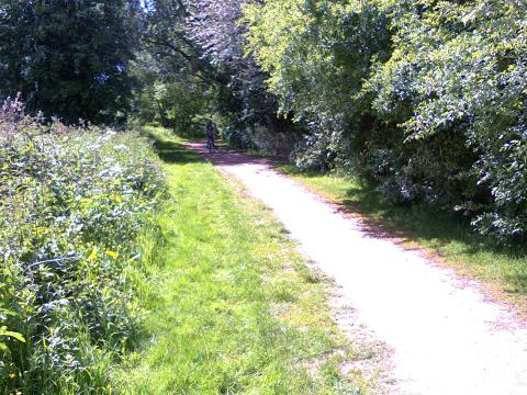 Once past this obstacle course, you're in the peace and natural beauty of the Woodgate Valley country park. If it hadn't been for Roy's map I probably would have never gone there, because until I looked at the map I thought it was a dead-end. There are two paths, one either side of the brook, and cyclists are supposed to use the northern path. However, the southern path was sunnier and consequently less boggy, so I opted for that (in Winter both paths would likely be impassable without knobbly tyres). There were lots of families out in the park walking and cycling, but whilst it was great to see children whizzing along on their bikes and having a great time, it was such a shame some of them had to keep stopping to wait for their parents, who were plodding along behind on foot. Have they forgotten what their children know?
What I didn't know, but the map told me, is that there is a quiet link between Woodgate Valley Country Park and Leaslowes Park in Halesowen. Of course parts of it make cycling slow and awkward, but it does mean that the Quinton Expressway and the motorway are not the barriers they appear to be. Whilst it was great to learn this from the map, this section did reveal some shortcomings. Firstly the map does not include minor roads, so it's impossible to look at the map and say "I want the third left", and if you do get it wrong then you have no chance of working out how you have gone wrong. Being able to count roads is very handy as it means you don't have to slow for every side road and locate the name plate. I appreciate there is a necessary compromise between clarity, map size, and scale, but could minor roads be marked with thin lines (ie without names)? This, combined with a couple of cartographic errors, and a five bar gate and "private land" signs erected by the golf course (presumably to deter passage along what I later learned is a public right-of-way), meant I had a hard time getting across to Mucklow Hill, but at least I know the route now.  On the positive side, the detour was via Breaches Pool, and I've wanted to take a closer look at that ever since I saw it whilst taking my original route to the Netherton tunnel.
Anyhow, I eventually made it to the Dudley N°2 canal on the opposite side of Mucklow Hill from Leaslowes Park, and from there I was on familiar territory. If you take this route, be aware that you will have to carry your bike over a steeply stepped bridge to get from the Mucklow Hill side of the canal to the tow path.
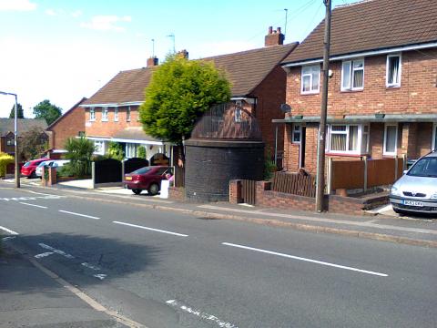
The tow path along the Dudley N°2 canal is in poor condition, and best avoided in Winter. Interestingly it does feature a short section of spray and chip path that was built just before those in Birmingham, and like those in Birmingham the chippings have worn off in patches. There is also a short section of the canal that has no tow path because the canal disappears into the Gosty Hill tunnel; cyclists have to climb a steep path and then travel by road over the top. This is probably just as well, because the tunnel is reputed to be haunted. As you take this road, keep an eye open for the "pepper-pot" tunnel vent in the front garden of an otherwise ordinary house.
 |
 |
 |
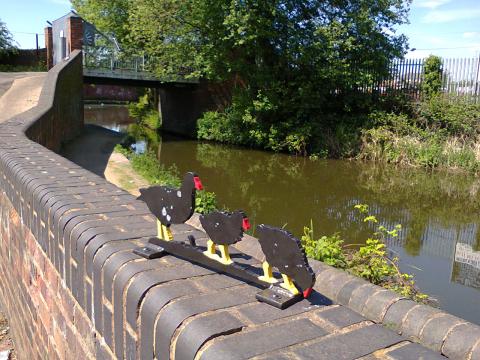
 The moorhens at the western end of the Gosty Hill tunnel mark the access point to the tow path, and (if you're heading west) a trail of other sheet metal artworks, such as the one on the right that offers a helping hand for those unsure which way to go on the Dudley N°2.
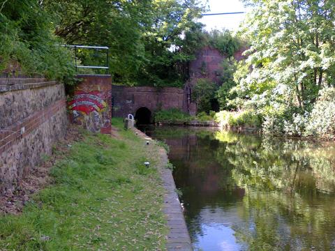
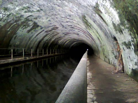
At the delightfully named Bumble Hole there is a convenient café stop, giving you the opportunity to fuel up for the long and gruelling ride through the Netherton tunnel. Actually it's not at all gruelling, but at 2,768 metres long it is one of the longest canal tunnels in the UK. It is also unlit. Originally lit with gas, this was later replaced with electric lighting powered by a water turbine at the northern portal (the turbine house can be seen in the photo below, the water being fed from the Old Main Line aqueduct above it). Today it is unlit, so it demands a powerful and reliable front light, and an equally reliable bike (there is no possibility of stopping to fix a puncture). It makes for a quirky bike ride, and when I emerged from the northern portal I met a group of young men who were greatly looking forward to cycling it in the opposite direction.
 |
 |
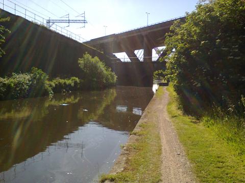 At the end of the Netherton branch a right turn takes you back to Birmingham along the Main Line. The tow path is initially poor, but it steadily improves as you head towards the city centre, making a good speed easily possible. However, it's still worthwhile looking out for pieces of industrial heritage, and infrastructure through the ages as it comes together along this green corridor.
Half way back to the city centre I was stopped by a woman with a large but beautiful and docile dog who asked me how long I thought it would take her to walk to Wolverhampton. She didn't care it would take hours; she was just going to keep walking, enjoying the sunshine and peace and quiet, and if she grew tired she planned to hop on the train back to Birmingham. We spent some time chatting, and she commented on how much safer the canal felt compared with the surrounding streets. Many people I meet who don't use the tow paths believe it's the other way around.
Once back in town it is possible to stay on the tow path, but given the path will be busy with pedestrians it is quicker and easier to follow the route of NCN5 past the library (hint: ignore the sign that directs you off the canal up a flight of steps, and instead go under the bridge and use the ramp on the opposite side), and then rejoin the canal at Waterfront Walk. From there one stays on the Worcester and Birmingham canal until University station, and then Bournbrook Walkway is reached via Vincent Drive. Once a horrible, narrow, busy road, where tail-gating and speeding was the norm, Birmingham City Council elected to close it completely to through motor traffic when the new hospital was built, and it is now a quiet cycling and walking route.
The complete route can of course be found on the Birmingham Greenways map, as a clear, green line. I'm not too bothered about the small problems I had with the map, because wayfinding a new route is always a bit problematic, and more importantly, the map has shown me a much nicer, greener route.
The Lapal Canal Trust
Many years ago I learned of the existence of the Dudley N°2 canal courtesy of a banner hung on the Worcester and Birmingham canal at the junction with the N°2 in Selly Oak. It had been placed there by the Lapal Canal Trust. It encouraged me to explore the N°2 between Selly Oak and Halesowen. In particular I was intrigued by the long-buried Lapal tunnel. At 3,470 metres it should be one of the longest canal tunnels in the UK, but there is almost nothing to see of it because the nature of the ground above it meant it kept collapsing, and in 1917 it was abandoned. In cycling out to the Netherton tunnel my intention had always been to get as close as I could to the original course of the N°2. Interestingly, my new route, as described in this article, not only gets me closer to the route of N°2 (despite it avoiding a short section near Leaslowes Park), but also it takes me close to the new, proposed route for the canal (through Woodgate Valley). The trust originally wanted to re-open the Lapal tunnel, but knowing its history I thought they were completely mad. Professional consultants Atkins (independently) agreed it wasn't such a good idea, and proposed a new route through Woodgate Valley. To me this slightly modified route looks splendid, and I hope it goes ahead (preferably with a nice wide tow path for cycling and walking). Alas I fear it will not happen, as Britain is penny rich and pound poor when it comes to infrastructure.
Last year I visited Assen in the Netherlands. In the past the Dutch adopted the same roads construction culture as the UK still does, and just as in the UK it resulted in death, a brutal environment, and the need to use every spare square metre for car parking. Having spent forty years reversing that trend, they now have too much road space and too much car parking, so they are removing it. This has allowed the local authority in Assen to dig out and reopen the canal that leads into the town centre. They even moved one of the remaining parts of the canal sideways by two metres.

