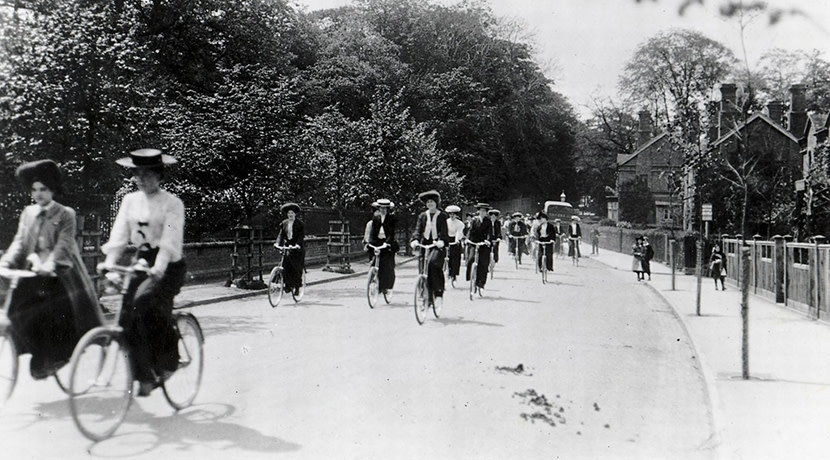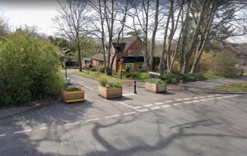
The Cadbury brothers intended Bournville to be a pleasant and quiet neighbourhood for the people that lived in it. It has many historic low traffic neighbourhoods, and there are footpaths cutting through between houses everywhere. The Cadbury brothers were keen "cyclers" (to use the contemporary word), but cycling infrastructure wasn't really a thing, because it wasn't needed. Cycling simply outweighed driving as a mode of transport (see photo at the bottom).
However, since then there has been an exponential rise in the use of private cars, with a significant proportion of that rise being in the past quarter century. The result is roads that were once used by "cyclers" are now rammed full of motor vehicles. The council's own research shows that around 50% of those vehicles are private cars making journeys that are well within the range of someone on a bike. The council would like to address that, which is great, but what does it propose for Bournville, and is the proposal any good? We urge you to respond to the consultation, which ends on the 2nd July. You may like to reference our own response below.
Modal Filters
Only three modal filters are proposed, and they would all be welcome. Two of the filters protect from rat-running the village centre, where small independent shops, Selly Manor, and the internationally famous carillon are located, whilst the third is used to protect a minor road and turn it into an active travel route. However, we feel that more are needed to return Bournville Village to being the quiet "village" intended by the Cadbury Brothers.
Some additional filters are mentioned in the text below, but a modal filter on Langleys Road would be beneficial as this is a useful cycling link that sees significant speeding, being a rat-run.
A38 to Bournville Lane On-Road Cycle Route
One of the proposed modal filters is on Oak Tree Lane. It is intended to stop rat-running along this proposed cycle route. Although this is generally a good route to cycle (because there are not too many motor vehicles), parts of Oak Tree Lane are very narrow and there are times when there are sufficient motor vehicles to make cycling on it feel unsafe (bullying by the drivers of oncoming vehicles being a particular problem). This additional modal filter, which supplements what is currently a pop-up filter at the junction with Woodbrooke Road, is therefore welcome. We also welcome the proposal to improve the junction at Bournville Lane, which is currently nasty, especially for people on bikes cycling against the significant incline across Bournville Lane.
Bournville Lane Cycle Route
This runs from the tunnel on the border with Stirchley down to the A38. This is a key road in Bournville, and that means it is busy with motor vehicles, with drivers routinely exceeding the speed limit. However, being a key road, that also means people need to be able to cycle on it safely. Unfortunately, not all is good in the proposal, though it does get better the closer it gets to the A38. The proposed design relies on of a lot of shared-use footways, which are in general poor for cycling. That makes them unpopular with people on bikes (creating a two-tier system in which the more confident, but not necessarily more able, use the carriageway), but also with pedestrians (who feel threatened by the presence of cycles).
The shared-use footpath on Bournville Lane past the station seems like an exceptionally bad idea, as it means people walking out of the station will step straight into the path of cycles on a narrow footway. This proposal looks especially poor if one considers larger forms of cycle, such as trikes (which are often used as mobility aids) and cargo bikes. On page nine of LTN1/20 Cycle Infrastructure Design it states quite simply, "Shared use routes in streets with high pedestrian or cyclist flows should not be used.". In our opinion a better solution would be to make Bournville Lane and Mary Vale Road one-way, with west-bound traffic passing down Franklin Way. This would create space for protected cycleways.
Once past the station, the shared-use becomes increasingly inexcusable as first a lane of car parking appears, and then a dual carriageway. Here there is plenty of space for a protected cycleway.
The proposed cycle route crosses the road at the existing zebra crossing near the playing field. This would at least need to be upgraded to a parallel crossing to be legally usable by cycles. We would urge that some thought goes into this, because there is a problem with drivers failing to see people waiting to cross. That was addressed to a certain extent by relatively recent changes to the crossing, but there is room for further improvement. There is a proposal to make it a raised crossing, but whilst theoretically that is a good thing, it may meet with a valid objection from the bus company.
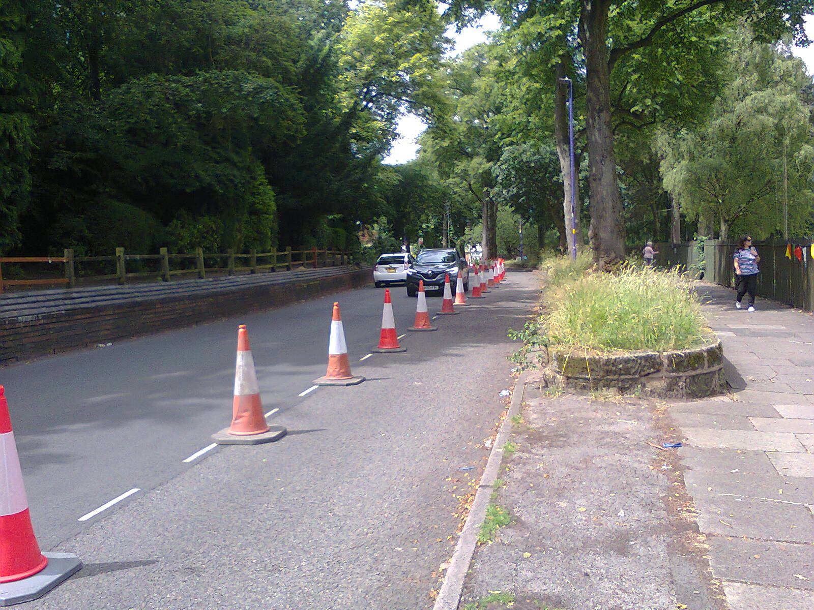
Beyond the crossing the footway is in poor condition and needs reconstruction (with asphalt) for shared-use. But again, there is a long line of parking spaces which could be taken away and converted into a protected cycleway. Indeed that effectively happens every year for the Bournville Festival (photo below).
The section of Bournville Lane past Beech Road goes over the top of a hill. We feel it would be preferable to upgrade the existing crossing on Linden Road that is close to the level path between Linden Road and Selly Oak Road to a toucan or preferably sparrow crossing. This crossing should respond promptly to a beg-button press. Making the path between Linden Road and Selly Oak Road shared-use would then allow those not needing to leave Bournville Lane between Hay Green Lane and Oak Tree Lane to avoid the peak of the hill. Lots of people ignore the existing Cycling Prohibited signs on this path already with no harm done. Indeed I have only met with positive interactions when cycling here.
Whatever is done, the junction with Beech Road needs attention, as it is difficult to exit Beech Road safely.
The shared-use beyond Selly Oak Road is surely on the wrong side, as it would mean cyclists crossing four roads as opposed to two on the opposite side (will cyclists on shared-use paths created for this scheme be given priority over side roads with properly set back crossing points, as is necessary to make the route attractive to use?). As proposed it would mean further complicating the already busy and dangerous crossroads with Hay Green Lane (it has poor sight-lines on a junction type that results in many more conflict points than a T-junction). The section of Hay Green Lane that runs up to Bournville Park is quieter (it has less less car traffic and is not on a bus route, and indeed is effectively part of the "pop-up" LTN). Swapping the shared-use to the opposite side from that proposed would also keep the shared-use on the same side as the proposed protected cycleway. It is not known if the pavements will be improved as part of the scheme, but they need to be.
The junction with Hay Green Lane badly needs improvement for all road users. However when I raised the problems it creates with the council many years ago, they were clearly well aware of them but also unwilling to change anything. No changes are proposed in the "Bournville Places for People and Cotteridge" plan.
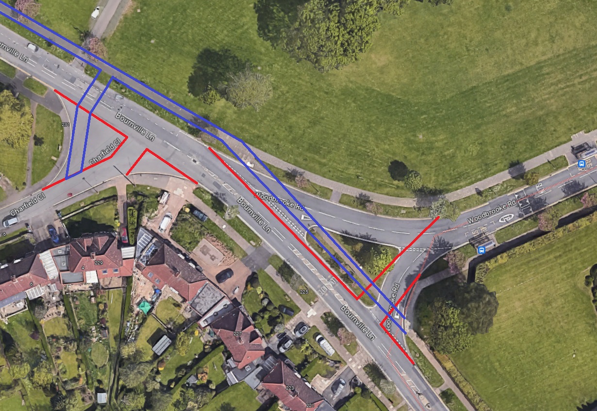
By switching the shared-use to the opposite side, the proposed signalised crossing near Woodbrooke Road is then not needed for the cycleway, but something is needed to help people get across Bournville Lane near Charfield Close. Charfield Close is a very useful historic LTN (much more usable than the Merritts Brook greenway through the woods). Both Charfield Road and Woodbrooke Road junctions are of a poor, outdated design, with much scope for improvement (see suggestion below). The current design of the Charfield Road junction results in some novel vehicle movements, whilst the design of the Woodbrooke Road junction encourages the speeding that is a problem here.
The Bournville Lane / Woodbrooke Road protected cycleway is a welcome improvement to the existing shared-use path than runs along part of Bournville Lane as part of the Merritts Brook Greenway. One thing it doesn't seem to address is the inadequate informal crossing that is part of this section of the greenway. This would be a good opportunity to downgrade the very narrow, unlit, shared-use path through the woods to a footpath, and have people on bikes use Charfield Close and the Cob Lane spur. However, a zebra crossing would still be needed here, and would help to make Bournville Lane less of a "motorist's blastway".
The protected cycleway needs to have priority over Meadow Rise.
Woodbrooke Road Cycle Route
Whilst the protected cycleway on one part of Woodbrooke Road is welcome, the shared-use section seems very questionable, as it will take cyclists on a narrow footway past sheltered housing for the elderly (see the earlier comments about the shared-use path outside the station). Personally I rarely cycle this way (it leads to the cycling nightmare that is Linden Road), preferring instead to use the Oak Tree Lane LTN and Bournville Park. A zebra crossing is proposed near Selly Oak Road, but it would not be legal for people on bikes to use this whilst following the on-road cycle route on Oak Tree Lane. It would be helpful to have some sort of roundabout at the junction, preferably one that cannot be driven over at speed. This roundabout could connect with the protected cycleway on Woodbrooke Road, to allow people on bikes to switch between the cycleway and the carriageway.
Mary Vale Gyratory System
Really? The people living on Mary Vale Road between Linden Road and Selly Oak road have long been complaining about the HGVs using this road, but HGVs are not the only problem, and a gyratory system in a residential area is never the answer. The idea is to force HGVs to make sharp turns so drivers re-route, but not only is it likely many will just opt to struggle rather than re-route, what about all the smaller vehicles that make this road a misery? The traffic is so heavy it can be difficult to cross the road, and at the Linden Road junction there are shops either side. Speeding is rife. I've seen one driver tooting at a teenage cyclist because he was "in their way". Just recently, whilst driving, I was tailgated along both sections of Mary Vale Road, with the person behind constantly trying to get past me even though there is insufficient width. The driver did eventually get past, only to get stopped at the traffic lights on the bridge over the canal. That gave me the opportunity to look in the half-open tailgate, which suggested this super-urgent journey was a trip to Lifford Lane Recycling Centre. A gyratory system will just make it easier for drivers to speed, spread the misery to Beaumont Road (which is currently a relatively quiet cycling route), and reduce cycling permeability (a trip to and from the shops will suddenly necessitate braving Linden Road, which is hardly a way to encourage cycling).
One-way streets in Low Traffic Neighbourhoods are typically used either to create an arrangement whereby someone entering the one-way system is fed back out a short distance away (so the road is accessible by motor vehicle, but unusable as a through-route), or two free up a lane to allow the creation of bidirectional cycleways. The proposed scheme does neither.
Long ago myself and another Push Bikes member, who is a civil engineer, proposed to the council a means of quieting this whole area. We proposed a modal filter between Franklin Way and Franklin Road, and additional measures to prevent motor traffic from using Mary Vale Road and Beaumont Road to bypass Bournville Lane. This is still Push Bikes' preferred option.
Heath Road Cycleway
The protected cycleway along Heath Road is welcome, though there is a big hurdle to jump, namely, how does it link with Heath Road South? The existing connection is two flights of steps with a rat-run between them, and the two sections of Heath Road are at different elevations. It would be useful to have cycling connectivity here, but not if it involves using the existing pedestrian connectivity.
There are also side roads to be crossed, and the cycleway needs to have priority over those. One exception to this would be at the junction with Woodlands Park Road. Kerb realignment is needed at Hawthorne Road to reduce radii.
The proposed shared-use path between Hole Lane and Cornfield Road is unnecessary, as traffic is light. However, beyond Cornfield Road drivers use the area as a rat-run between Bunbury Road and the A38, so we would suggest modal filters on Cornfield Road and Dinmore Avenue in preference to shared-use pavements. This will also make it easier to cross St Laurence Road to access Victoria Park. That change may result in a need for a modal filter on the section of Hole Lane that connects with Cornfield Road if motor traffic diverts.
Cob Lane and Hole Lane One-Way Streets
The purpose of these one-way sections is unknown, but it possibly relates to the roads being very narrow. Both roads endure a lot of traffic, and Hole Lane has become very apposite as that traffic has torn up the asphalt. The bottom of some really quite ordinary cars hit the speed cushions.
Alas the proposal will simply divert the heavy motor traffic on to Old Barn Road, which is currently very useful for cycling as it's very quiet and it links with Charfield Close via a short path (ie it's part of a historic LTN). That cycling link could be improved by giving giving Old Barn Road priority over Hay Green Lane and reducing radii, but that would be pointless if Old Barn Lane is suddenly subject to heavy traffic.
Part of Hole Lane is also useful as a parallel cycle route between Northfield and Selly Oak, and the proposed one-way on Hole Lane would kill that route in one direction unless there is a cycling contraflow. Indeed both these one-way streets will reduce permeability for cycles.
Griffins Brook Lane
This would be a good opportunity to correct the mistake made when part of Griffins Brook Lane was made one-way with no cycling contraflow. It would be better to close the road to motor traffic between Alder Lane and the A38, so all motor traffic can do is loop around Alder Lane and emerge where it came in. Push Bikes suggested this at the time, which got the approval of Cllr John O'Shea, but our suggestion was ignored.
Woodlands Park Road / Northfield Road / Bunbury Road Junction
This junction is atrocious, yet nothing much is proposed here despite there being a protected cycleway that runs from the junction down to Popes Lane. We would suggest filtered permeability at the end of Northfield Road, and a single toucan or sparrow crossing over Bunbury Road on the Northfield Road side of the junction. There is a huge amount of space here to provide a reversing point on Northfield Road.
Traffic Calming
Traffic calming is proposed for the area. Traffic calming in Birmingham mainly consists of cushions and pinch-points. These make cycling more dangerous, as drivers perform dangerous overtakes to try to beat cyclists into the traffic calming measure. They should not be used (and existing such measures should be removed). Speed tables, preferably with cycle bypasses, are much better. We are aware that these cause problems for buses, but that is where cycle bypasses become essential (because cushions become the only option). However, it's worth adding that cushions also have no effect on any large vehicle, including SUVs, so they are effectively encouragement for drivers to switch from small cars to SUVs.
As a general rule it is far better from a cycling perspective to reduce motor traffic rather than to add traffic calming.
Junction Radii
We commend the proposal to realign kerbs to reduce radii, but this change will need to be widespread. Bournville is in many ways good for cycling and walking, but the junctions are very dated in design, being from an era when cornering speed was limited by suspension geometry.
Space for Cycling on Bournville Lane
BournvilleLane / CharfieldClose / WoodbrookeRoad Junction Proposal
Workers Cycling to the Cadbury Factory 1905
